
In which The Author hits the great outdoors again
This chapter is somewhat unusual in including a Health and Safety warning.
DO NOT ATTEMPT TO EXPLORE THE AREA DESCRIBED HERE WITHOUT SUITABLE FOOTWEAR AND OUTDOOR CLOTHING, AND (PREFERABLY) A COPY OF THE ORDNANCE SURVEY MAP OL 12 (Brecon Beacons National Park: West and central areas).
[A digression: I’m just covering myself here, in case any of you are inspired to follow in my footsteps. I was walking around Penderyn one day in July last year when a middle-aged couple asked me for directions to the Sgwd yr Eira waterfall (see Going Down the River). He was carrying a fairly old copy of the Reader’s Digest Road Atlas, which is fine if you’re driving, but fairly light on detail otherwise.
Almost instinctively I glanced down at their feet. He was wearing trainers; she was wearing sandals.
‘You must be joking!’ I said. ‘You really aren’t dressed for the walk over there.
After a few minutes I managed to talk them out of their plan, and directed them to Pontneddfechan instead. Their footwear wasn’t ideal for that terrain either, but at least they could see some nice waterfalls without risking their necks into the bargain.]
Yesterday morning I felt like getting out of Aberdare for the day. I wasn’t in the mood for Bores and Lo Teks. I wasn’t in the mood for people at all, to be honest. I listened to the first half of Ken Bruce’s radio show, and after ‘Popmaster’ I headed for the hills.
Stagecoach offer a Day Rider ticket for £4.80, which is valid on all their buses in and around Aberdare. (Admittedly, that only means it’s good until about 1830 in reality, but that was plenty of time for me to get out and about.) I caught the 1050 departure to Glynneath from the stop near my house, and by 1130 I was well on my way to the back of beyond.
When we reached Glynneath, I got off opposite the Halfway House and walked the mile or so to Pontneddfechan. This is the village I mentioned in Going Down The River, where a number of smallish rivers converge at the head of the Neath Valley. I’ve explored the Nedd Fechan stretch on many occasions, so I decided on another route this time. I walked through Pontneddfechan as far as the Dinas pub, then took the steep road uphill, heading for Ystradfellte. I was (just about) inside the borders of the Brecon Beacons National Park.
The early part of the walk took me through Millionaires’ Playground, a winding road lined with very impressive detached houses, and as far as the village school. There was no sign of life there, and I assume it’s closed. I carried on walking past the golf club and within a few minutes I’d left the houses behind. I emerged onto a fairly level stretch of road, with open moorland to my right and farmland on my left.
In the distance, the increasingly familiar wind turbines had positioned themselves on the mountain top. Coming back from the hospital with Rhian a fortnight ago, I teased her that the turbines were attacking Aberdare from all sides. It seems that Aberdare’s not alone.

When I looked back towards Hirwaun, I saw more turbines. I’m fairly sure these must be the same ones which Rhian and I got fairly close to when we walked around the horseshoe in Dare Valley Country Park a while ago.

I carried on walking, surprised by how little traffic there seemed to be. A Royal Mail van had driven past me a few minutes earlier, obviously delivering to the scattered farms on this high ground, but I hadn’t seen much in the way of tourists. It’s still comparatively early in the summer, I suppose.
There were plenty of sheep around, of course. They roam freely on the moors, keeping the vegetation under control and occasionally darting in front of cars. There was also a lot of logging going on. The first sign was a huge pile of timber just inside a fence at the side of the road.

Although I hadn’t (very) long had breakfast, I decided to start on my packed lunch here. I arrived at a junction between my minor road and an even smaller track, marked with some large boulders. I sat on one of the boulders, ate a pasty, drank some water, and examined the map for a couple of minutes. If I followed the track, I’d eventually emerge at Pont Melin-fach, further up the Nedd Fechan, from where I could walk back into Pontneddfechan. That seemed a bit of a waste of the day, so I pressed on for a while.
There are fine views in all directions once you hit the high ground. Just look at the spread of the Brecon Beacons, facing approximately west from here.

A few minutes after this point, I found a wooden signpost for Sgwd Clun-gwyn, pointing down a gravel track towards a farmhouse. There are so many waterfalls in this area that it’s difficult to remember which ones I’ve visited previously, and which ones are new to me. I decided to take a chance, and made my way through the gate towards the farm. The path skirts the farm buildings and leads downhill through thick deciduous woodland. At this time of year, I was pleased to see the ground carpeted with bluebells. Mother loves a bluebell wood, but they’re increasingly rare these days.

We’d had some torrential rain on Sunday and Monday. It must have helped to swell the upland rivers hereabouts, because I could hear the roar of the waterfall long before it came into view. A middle-aged couple (wearing appropriate gear, I’m pleased to say) were approaching from the opposite side, accompanied by a golden labrador. (I was relieved that Stella wasn’t with me, because she’d have dived straight into the raging water and ended up miles away.)
There’s a fenced-off area just above the waterfall itself, which gives you a decent view.

I decided to try and get a bit closer, though. I scrambled down the slope and made my way over some large rocks to reach the shelf which breaks the fall into two stages. The upper drop is a bit higher than I am tall (just under six feet), and the crashing water was unbelievably loud as it cascaded into the gorge below. I clambered over more large rocks and eventually reached the bottom, where the river Mellte has carved out a deep gorge in the rock.


As you can see from the photos, even after the downpour earlier this week, the river flows over only about a third of the width of the shelf. It must be a terrifying sight in the middle of winter, when it rains heavily and continuously for days on end.
I made my way back to the top of the fall and walked onto the dry area. The rock here has been eroded into a strange undulating surface.

On the opposite side of the river, another couple were taking photos from their vantage point some distance above the fall. Having established that I was on the Mellte, I now had a couple of options open to me. I could try and follow the river downstream and eventually re-emerge in Pontneddfechan. Unfortunately, I didn’t know whether the whole way would be passable after all that rain. I didn’t fancy getting halfway and then having to turn back. I wasn’t even sure whether there was a path the whole distance. I’m fairly sure that this was where Phil, Jason and I had got lost when we did our mystery trip to the waterfall country.
Alternatively, I could head upstream and arrive at Ystradfellte via the Blue Pool and Porth yr Ogof. (Yes, I know the Firefox spellchecker is whimpering in the background again; just try and ignore it.) I knew my way to the Blue Pool, so it seemed a sensible plan. I found a narrow path along the river bank and struck out northwards.
The river here is quite smooth and gentle, with no hint of what awaits a few hundred metres downstream. It wouldn’t be any good for canoeing, of course, and probably much too cold to paddle in, but I expect there’s some decent fishing along this stretch.

I’d only been walking for a minute or so when I came to a narrow bridge across the river. It took me to the opposite bank, where two wooden signs pointed in different directions. One pointed to Swgd yr Eira, and gave the walking time as thirty-five minutes. The other pointed to Cwm Porth car park. That sounded promising; I knew my way there.

Now that I was on the other side of the river, I decided to walk as far as the waterfall and get a look at it from above. The path wasn’t as easy as I’d hoped, and it involves a bit of up-and-down scrambling in places. A few minutes from the bridge, though, I found the viewpoint I’d been aiming for.

I retraced my steps to the bridge, and met a small party of students heading downstream.
‘Excuse me,’ one of them said, ‘is there another waterfall along here?’
‘Oh yes,’ I grinned. I gave them brief directions to Sgwd Clun-gwyn, and added, ‘It’s a whopper!’
They got very excited when I told them that, and headed off eagerly. In the meantime, I followed their footsteps back along the river bank. This is another part of the route where you need sensible walking boots. Just look at the way the path winds in and out of the tree roots here.

A few minutes further along, the path emerged onto a large flat grassy area. The river was some distance below, rushing along with renewed vigour. I was approaching the Blue Pool.
When I was growing up, the Blue Pool was a bit of a legend in our circle of friends. The cyclists amongst us would often set off for this mysterious destination; it was a popular picnic spot for families with cars, too. I never knew where it was until Mother and I were driving around one day, and asked somebody for directions. It didn’t exactly live up to its bill matter.
The Blue Pool is just downstream of the point where the Mellte emerges from a brief spell underground. The water must be bitterly cold (I’ve never braved it myself), and I can only assume that it takes its name from the skin colour of those reckless people who do take the plunge. Having said that, there’s a large rock which slopes gently to the water’s edge, which must be a great spot for a picnic when the sun is blazing down.


The terrain here is fairly challenging, too, and just getting to the Blue Pool on foot is a bit of an expedition. It’s a few minutes’ walk from the car park at Cwm Porth (currently £4.00 for a car, £7.00 for anything larger, in case you’re tempted). In between the car park and the Blue Pool, there’s a rather frightening chasm in the ground where you can hear, but not see, the Mellte as it barrels its way underground.

There’s a little shop-cum-tourist information kiosk in the car park, and well-maintained public toilets nearby. When I arrived at the car park a small party of walkers were setting off downstream, and a large group of schoolchildren were kitting themselves out to head into the cave system. I finished my lunch and had a breather at one of the picnic tables, wondering which way to go next. I wanted to get some photos of Porth yr Ogof before I headed off again, and it seemed as though Ystradfellte was closer than I’d thought. It was still comparatively early, so I decided to kill some time here before moving on again.
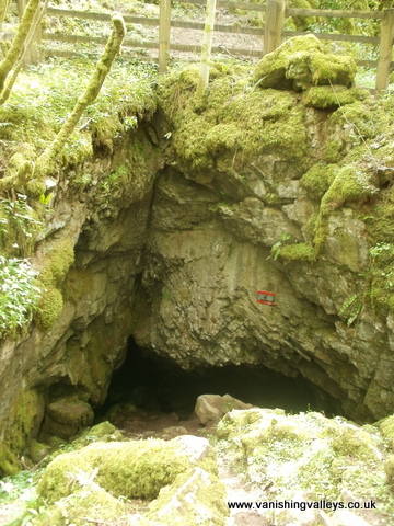
There’s a steep path from the car park to Porth yr Ogof, and one group of youngsters were climbing the stile when I reached the bottom. I looked around and spotted a small cave behind me. I hadn’t noticed it on my previous visits, so I decided to check it out. I had no intention of entering it, of course – and that idea was reinforced by a notice I found a few metres from the entrance.

It doesn’t exactly inspire confidence, does it?
While I was taking a couple of photos a group of about a dozen youngsters arrived behind me, with two adults to supervise their progress underground. One young lad sounded quite apprehensive at the idea of heading into the cave, and I smiled at them.
‘I know exactly what you’re thinking,’ I said. ‘Suddenly double maths doesn’t seem like such an awful proposition.’
The adults and some of the kids laughed, and then they gradually made their way into the cave. Rather them than me!

I made my way around to Porth yr Ogof, the huge cave that marks the entrance to this particular subterranean labyrinth. Another group of youngsters were already inside, making their way into a very small gap at one side of the mouth. I could feel the temperature plummeting as I approached the entrance, and I could see my breath misting as I followed the river inside. I didn’t venture too far inside, but I got some fairly decent photos.


The approach to the cave was partly blocked by some colossal sandstone boulders which have fallen from the slope above. It’s no wonder the signs nearby warn people of falling rocks. Each one of these was about the same height as me, and they must weigh several tonnes apiece.

I made my way back up to the car park, where I had a choice of routes again. I could either rejoin the minor road and walk into Ystradfellte that way, or take a footpath from the end of the car park and arrive at the village across some farmland. The chap from the shop assured me that the way across the farmland was straightforward (yes, it’s that word again!), so I set off.
The first part of the path was straightforward, following a dry stone wall through some woodland and then along the edge of a field. Then, needless to say, the waymarkers dried up. I didn’t want to double back, so I climbed over a low fence and into a field with no sign of livestock. I carried on heading north and soon became aware that I was walking into a farmyard. I wondered how I’d be explain my detour to an angry farmer, but I didn’t need to. There was a large tractor parked between the house and a barn, but no other sign of life. I strolled through the farmyard and out along the driveway to the minor road beyond.
I’d emerged slightly east of Ystradfellte, so I followed the road downhill until I reached a bridge across the river. Just beyond lay a blue sign, announcing that Ystradfellte had won the title of Powys’ Best Kept Village in 2004. Beyond that lay the village itself.

As with Llanwynno, calling Ystradfellte a ‘village’ is stretching the definition. There’s a handful of houses, a very nice sandstone church, an old phone box, a new village hall, and a shop (which was closed. I was in Powys. It was a Thursday afternoon. Go figure!) Most importantly, there’s a pub – and it was open!


Last time I was in the New Inn, it was with Mother, several years ago. We’d called in for lunch, which wasn’t up to much, and we never bothered going back after that. I heard a while ago that it had changed hands, so it seemed rude to walk past without checking it out.
I was glad I decided to give it a second chance. The barmaid was very friendly and welcoming, even though it seemed that I was the only person in there. They have an extensive menu, including a selection of vegetarian and vegan dishes, and they had some very tempting cakes at the end of the bar. I paid £3.00 for a pint of lager, which is average for this part of the world, and went to sit in the beer garden. No traffic came past, and there was hardly anyone else around.
From my vantage point, I was able to watch a crow occasionally ducking into a hole on the roof of the barn opposite. Each appearance was greeted by a chorus of harsh cries from inside, and it seems that there was a nest hidden beneath the old slates.
When I was looking around the pub, I’d spotted a nice sign on the wall. I don’t know whether J. R. R. Tolkien originated this saying, but he definitely used it in his books. It seemed appropriate for the afternoon’s adventure.

‘Not all that wander are lost; some of them are just wondering what happened to the right of way signs.’
I drank up and headed back to St Mary’s Church for a look around. The building was locked, of course, but there were some interesting monuments in the graveyard. Amongst the older ones there were a couple of headstones commemorating people from Blackwood, of all places, and a huge memorial to a doctor who had served in India before returning to Wales. The graveyard is still used for burials, and there’s an appeal to raise funds to renovate the building. It would be a shame if it was allowed to fall into disrepair after standing there for so many centuries.
It’s a steep, winding climb from Ystradfellte towards the A4059. The main Aberdare to Brecon road is only few miles distant as the crow flies, but as the walker walks it seems like double that. The minor road runs through the middle of a large forestry plantation, and logging was under way in a grand fashion. Look at this lot, just piled up waiting to be transported to wherever logs go.

I glanced round at one point, just in time to see a tree crash to the ground behind the fence. There’s a superb view from here, but without a tripod it was difficult to get a decent panoramic shot. This will have to do for now.

I was on a downhill stretch when a car came towards me and pulled up. A youngish couple asked me where they could find ‘the waterfalls’, and I told them they were spoilt for choice. I advised them to head for Sgwd Clun-gwyn, as I’d seen it for myself that afternoon and knew it was worth seeing. I gave them fairly decent directions (for a non-driver, anyway) and they set off again. I hope they managed to find it. If they didn’t, they’d soon have found one of the others easily enough.
As I was approaching the junction with the A4059, I spotted a hangover from our local area’s recent(-ish) history. I need to mention this to Cerith when I see him, as a possible photo opportunity for his blog.

I emerged onto the A4059 near a lay-by where an ice cream van is always parked during the summer. I wasn’t surprised to see the ice cream van, but I was surprised to see a bus pull in to the lay-by. It was in NAT colours, and had a destination indicator reading ‘Abercrave’. I can’t explain why it would have appeared there, miles from Abercrave on completely the wrong road, but it’s given me a bit of a research project. If NAT buses do cover that area, it opens up a bit more scope for the Vanishing Valleys project.
The walk into Penderyn along the A4059 isn’t for the faint-hearted. It’s not particularly arduous; in fact, it’s a fairly easy stroll over some gently rolling hills. However, vehicles travel along that road at a hell of a pace. Since there’s no pavement on either side, the Highway Code recommends that you walk on the right, facing oncoming traffic. Luckily there’s a fairly decent verge for most of the distance, so I was able to step up and out of harm’s way as trucks, coaches, artics and tankers thundered past just a couple of feet away. You certainly couldn’t do it with a dog in tow, much less a pushchair.
I made it into Penderyn just after 4.30, and called into the Lamb Hotel for a can of ginger beer. Phil, the landlord, was surprised to see me, so I told him how I’d come to be there on a random Thursday. He asked to be remembered to Mother, and in return I promised him I’d try and make it to the church fundraiser on 24 June. (That’s not the Ystradfellte church appeal, mind. It seems that St Cynog’s, on the hill overlooking Penderyn, is also in need of a facelift.)
I was back home by 5.30, and started making something to eat. I was toying with the idea of karaoke in the Lighthouse, but by the time I’d eaten and had a nice hot bath, I decided an early night was called for. I played with the photos for a while, and then dozed off in the chair while listening to Radio 4. Instead of being in town until midnight, I was in bed just after 10pm.
Not bad going for a Bore- and Lo Tek-free Thursday, was it?


You must be logged in to post a comment.